Colorado Fishing
Arkansas River Headwaters Fishing Map - North


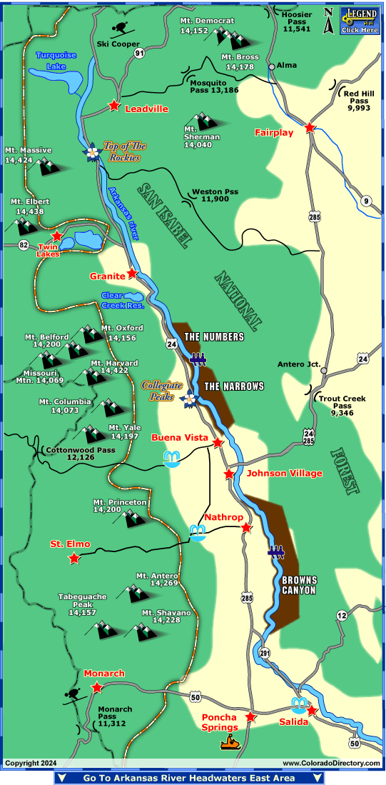
The north portion of the Arkansas River is located 90 miles west of Colorado Springs, and 120 miles southwest of Denver. The river flows usually peak between the 1st and 3rd week of June. This section of the river follows closely to US Highway 24, until the junction of Highway 285 where it follows it down to Salida. The area is also accented by the many 14ers scattered around the river.
The Browns Canyon is a spectacular place for scenery and adventures down the river. Here you can enjoy stunning granite rock formations that are accented by the clear blue Colorado sky. The granite walled canyon holds the river below filled with boulder-strewn waters followed by calm pools, scattered with exciting class III rapids. Enjoy incredible views of the 14,000 foot peaks of Mt. Princeton, Mt. Antero and Mt. Shavano.
The section of the Arkansas River known as the Numbers is the roughest white water on the river. Here, class IV-V rapids flow through a narrow, rocky and steep canyon. Advanced skills are required to negotiate through the steep and technical drops, tight maneuvers, huge holes and powerful waves. Helmets are provided by most outfitters, and at times, wet-suits may be required.
For some time of relaxation be sure to visit the Mt. Princeton Hot Springs, Cottonwood Hot Springs or the Salida Hot Springs Aquatic Center. The Mt. Princeton Springs will relax your tired body in its 135 degree water, as you sit under the 14,000 foot mountain peaks that surround you. These hot springs are located between Nathrop and St. Elmo. The Cottonwood Hot Springs are located near Buena Vista, This retreat emphasizes the pure, gravity-fed, natural hot springs, rock-lined soaking pools, private adult-only spas, cold plunge and sauna. The Salida Hot Springs is Colorado's largest indoor hot springs pool facility. Natural spring water is transported by pipeline from Poncha Springs.
Downhill skiing is also offered at the Monarch Ski Area and Cooper Ski Resort. Monarch Ski Area is situated in the San Isabel National Forest in South Central, Colorado. The average snowfall is 350 inches! Cooper Ski resort is known for its less crowded slopes, bringing Alpine Skiers, Tele-markers, Cross-country Skiers, Snowboarders and Snowmobilers.
Be sure to also travel along the many mountain passes located in the area. Trout Creek Pass (9,346'), Red Hill Pass (9,993'), Hoosier Pass (11,541'), Weston Pass (11,900'), Cottonwood Pass (12,126') and Mosquito Pass (13,186') are all located in the area. Also be sure to travel the Top of the Rockies Scenic Byway, traveling 75 miles starting in Twin Lakes, through Leadville to either Minturn or Copper Mountain, literally at the Top of the Rockies.
More Local Information
Buena Vista Area, Colorado includes: Johnson Village, Nathrop, St. Elmo
Leadville & Twin Lakes Area, Colorado includes: Granite, Twin Lakes
Salida, Colorado includes: Howard, Monarch, Poncha Springs


