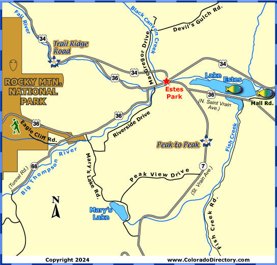
Local Area Map
Estes Park Area Map


Not all towns appear on map. The publisher does not assume any responsibility for accuracy or completeness of maps. This information was compiled as accurately as possible.
When Joel Estes first visited the Estes valley on a hunting trip in October of 1859, he thought the valley held promise as a cattle ranch. He and his wife Patsy moved the family into two log cabins near what is now Estes Park. In 1864, William Byers, then editor of the Rocky Mountain News, attempted scaling Longs Peak. Byers and his companions stayed with the Estes family, and then named the area in honor of his hosts. The public soon learned about the beauty of the high mountain valley surrounded by snowcapped peaks when Byers later published his adventures from climbing Longs Peak. Soon others came to trap, prospect, hunt, and view the scenery, and after the Stanley Hotel was built in 1909, tourism increased even more. Though the area never gained reputation as a cattle ranch like Joel Estes thought, the town has become one of the most visited places in Colorado.
Today, a visit to the town ensures no boredom. The streets of Estes are lined with numerous candy stores and craft shops. There are also many places for miniature golf, horseback riding, or sailing. Be sure to ride the summer cable tramway to the top of Prospect Mountain. At the top, you will find a breathtaking view, a short hiking trail, photographic points and a snack shop for that mountain top picnic.
Climbing to the summit of Longs Peak is a favorite activity for visitors to the area. Two different trails lead to the top of the peak, North Longs Peak Trail and East Longs Peak Trail. Both hikes are difficult and take 14-17 hours, but worth the amazing view of the Estes valley.
Rocky Mountain National Park is another favorite place to tour. The eastern gate to the park is located at the edge of Estes Park. Rocky Mountain National Park is also home to Trail Ridge Road, the highest continuous paved road in the United States.
Estes Park Activities & Maps
National Parks and Monuments:
Rocky Mountain National Park
Scenic Byways:
Cache la Poudre - North Park Scenic Byway
Peak to Peak Scenic Byway
Trail Ridge Road Scenic Byway
Hiking Trails:
Rocky Mountain National Park Hiking Trails
Fishing:
Big Thompson River Fishing Map
Lake Estes Fishing Map
Rafting & Kayaking:
Cache la Poudre River Rafting & Kayaking
Jeep & 4WD:
Roosevelt National Forest Jeeping & ATV/UTV Trails
Snowshoeing:
Rocky Mountain National Park Snowshoeing Trails
Local Area Maps:
Estes Park Area Map
Rocky Mountain National Park Area Map
More Local Information
Estes Park, Colorado includes: Drake


