
Colorado Fishing
Blue Mesa Reservoir & Gunnison River Fishing Map
Click Areas on Map for More Fishing Information

Kokanee Salmon Fishing in Colorado's Southwest
The Blue Mesa Reservoir & Gunnison River Area is located between Montrose and Gunnison in Southwest Colorado. You'll encounter many different environments while fishing: deep canyons, wide-open reservoirs, forest filled walks. Like most of Colorado, this area is filled with various kinds of trout: Brook, Brown, Rainbow, Native Cutthroat, and Lake. You can also catch Yellow Perch and Kokanee Salmon in certain areas specified below.
Gunnison River Area Public Fishing Access
Gunnison River through Black Canyon of the Gunnison National Park - Gold Medal Waters run through the Black Canyon of the Gunnison; this area has some of the largest trout in Colorado. Please keep in mind, if you catch a rainbow trout you must release it immediately; do not bag it. Only non-motorized boats are allowed on the river, you must only fish with artificial flies and lures, and the only area you are allowed to fish is north of the Crystal Reservoir dam. Access is limited and generally only by foot or horseback.
Cimarron River - Fed from the Gunnison River, you are in Gold Medal Water territory if you're on the Cimarron River. There is no boating allowed. The only time you are allowed to bag a Kokanee Salmon is between November 1st and December 31st. Access is along P77 Road south of Cimarron.
Lake Fork of the Gunnison - 14 miles of fishing access gives you plenty of opportunity to find plenty of large fish; the average fish size is 10-16" long. Only non-motorized boats are allowed. All rainbow trout must be returned immediately to the water (catch and release) and you can only use artificial flies and lures on the river. Some access points include Sapinero Canyon and Smock Ranch. Access to this river is partially along Hwy 149.
Soap Creek & West Elk Creek - Both of these creeks are fed from and located north of the Blue Mesa Reservoir. There are no roads along these creeks so you'll have to be adventurous and trek it on foot. At the entrance to Soap Creek there is a boat ramp for Blue Mesa Reservoir. Elk Creek also has a marina near the entrance.
Blue Mesa Reservoir Public Fishing Access
Crystal Reservoir - The Crystal Reservoir is right in between Morrow Point Reservoir and the Gunnison River. Motorized boats are allowed on this reservoir. You can only catch Kokanee Salmon between September 1st and December 31st. You can access this reservoir via Hwy 50. Fishing is prohibited a few hundred yards downstream of the dam.
Morrow Point Reservoir - Fed from Blue Mesa Reservoir, motorized boats are allowed on this reservoir and you can only catch Kokanee Salmon between September 1st and December 31st. Access to this fishing is either by Hwy 50 or Hwy 92. Fishing is prohibited a few hundred yards downstream of the dam.
Silverjack Reservoir - Located south of Cimarron in the Uncompahgre National Forest, the Cimarron River feeds into the Silverjack Reservoir. Access to this reservoir is via P77 Rd. Only non-motorized boats are allowed.
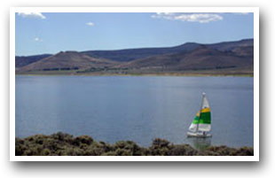
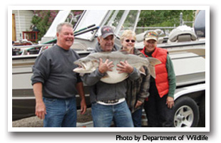
Blue Mesa Reservoir - The Blue Mesa Reservoir is Colorado's largest body of water. It is also the largest Kokanee Salmon fishery in the US and you can only be caught between November 1st and December 31st. Ice fishing is permitted on the reservoir but all ice fishing shelters must be portable; the best area to ice fish is near Lola Basin. Motorized boats are allowed on the reservoir and there is no bag or possession limit on Lake trout. Besides trout and salmon, you can also catch yellow perch in these waters. Fishing is prohibited a few hundred yards downstream of the dam.
Places to Stay & Fun Things to Do
SECLUDED year-round in the Uncompahgre National Forest! Arrowhead Mountain Lodge: Restaurant, bar, UTVing, fishing, snowmobiling. Near the Black Canyon between Montrose and Gunnison off US 50.
A PREMIER FISHING EXPERIENCE in GUNNISON: Guided lake and trolling for Rainbow Trout and Kokanee Salmon on Blue Mesa Reservoir. WINTER Ice-fishing from Mid-December to Late-March.
More Activities & Information
Gunnison, Colorado includes: Almont, Blue Mesa Lake, Ohio City, Parlin, Pitkin, Sargents, Sapinero, Taylor Park, Waunita Hot Springs
Lake City, Colorado includes: Powderhorn
Montrose Area, Colorado includes: Cimarron, Olathe
Fishing in Colorado